The role of GNSS in precision agriculture auto steering
Abstract
Global Navigation Satellite Systems (GNSS) are transforming agriculture by powering auto steering systems that improve efficiency, reduce input costs, and promote sustainability. This article explores how GNSS works, key satellite constellations, and the technical processes that make centimeter-level accuracy possible in modern farming.
1. What is GNSS and why does it matter in farming?
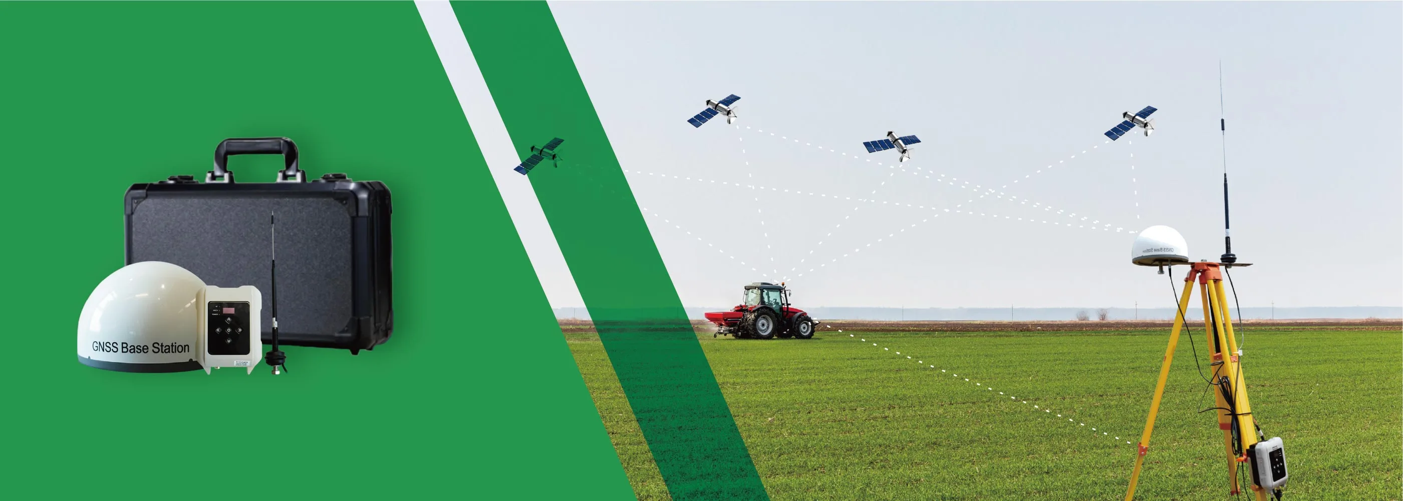
GNSS (Global Navigation Satellite Systems) refers to networks of satellites that broadcast positioning, navigation, and timing (PNT) data to receivers on Earth. By calculating how long it takes signals from multiple satellites to arrive, a GNSS receiver can pinpoint its exact location.
For agriculture, GNSS is the backbone of precision agriculture. The main building blocks include:
- Space segment: satellites orbiting Earth.
- Control segment: ground stations that monitor satellites and keep their data accurate.
- User segment: receivers and antennas mounted on tractors and other precision agriculture devices.
- Augmentation systems: correction services that boost raw GNSS accuracy to the level required for auto steering systems.
2. The constellations behind GNSS
Modern farm equipment uses multi constellation receivers, meaning they can "see" satellites from multiple systems at once. This ensures wider and more reliable coverage. The primary global and regional systems utilized in agriculture are:
- GPS (United States): the original system, now modernized with stronger civilian signals (L2C, L5).
- GLONASS (Russia): valuable for high latitude coverage and improving availability in hilly terrain.
- Galileo (European Union): a newer, highly precise system offering authentication features.
- BeiDou (China): now global, adding another layer of redundancy.
In summary, multi-constellation matters because more satellites in view mean fewer signal dropouts, leading to better accuracy under trees or near hills, and overall stronger system performance.
3. Why farmers rely on GNSS today
With the help of GNSS technology, precision agriculture and smart farming enable the following by providing accurate location data:
- Mapping and data layers: soil sampling, yield mapping, and variable rate application (VRA) all start with GNSS coordinates.
- Input savings: auto steering reduces overlap and missed spots in planting, spraying, and fertilizing, cutting seed and chemical use by 5 to 15 percent.
- Fuel efficiency and flexibility: operators can work in dust, fog, or at night, extending working hours and reducing labor needs, a key factor in achieving labor savings.
- Soil health: consistent wheel tracks reduce compaction in the root zone, improving crop growth.
4. How GNSS auto steering works
Achieving centimeter-level accuracy in the field is a multi-stage process that begins with satellite signals and is refined through sophisticated ground-based corrections. The workflow is as follows:
Step 1: Receiving raw data
A high precision GNSS receiver on the farming tractor collects signals from multiple constellations. On its own, this provides accuracy of about 1 to 2 meters.
Step 2: Applying RTK corrections
Real Time Kinematic (RTK) correction improves accuracy to 1 to 2 cm. A local base station or virtual reference station network calculates errors and sends correction signals to the farming tractor via radio or cellular connection (NTRIP). The receiver then applies these corrections for pinpoint precision.
Step 3: Steering control
Corrected position data feeds into the auto steering system's tablet, which compares the farming tractor's actual path to the planned path (straight lines, curves, pivots, or preloaded maps). Steering adjustments are made automatically using electrohydraulic valves or electric motors, enabling precise navigation for tractor operations.
Step 4: Implementing integration
With ISOBUS (ISO 11783), the farming tractor shares position data with farming implements. This enables features like section control, automatic row shut off, or variable rate adjustments, ensuring every seed, drop, or granule lands exactly where it should.
5. Conclusion: GNSS as the backbone of smart farming
GNSS is no longer just a navigation tool. It is the foundation of precision agriculture. Multi-constellation receivers, combined with RTK corrections and auto steering systems, allow farms to cut costs, boost productivity, improve fuel efficiency, and reduce their environmental footprint.
For today's professional growers, investing in high accuracy GNSS is not just a technological upgrade. It is a strategic decision to stay competitive, efficient, and sustainable, delivering labor savings and maximizing the value of precision agriculture devices.


